surfaces

surfPPC by James J. Lemon Graphics
©2005 All Rights Reserved.

JJLG software index
Online
surfPPC User Manual
surfPPC gallery
Free Demo
download
surfPPC v.287
The
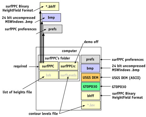
download: It's a *.sit (Aladdin Stuffit) archive containing:
1)
surfPPC executable (MacOS7.x-9.x) and keyword file "surfPPCrc" which
must be in the same folder as the application.
If
surfPPCrc is not found, it will run in "Demo Mode", in which saving
is disabled after 2 minutes each launch.
New
in version 287 (May 30, 2003)
The Ever Winding Path to OSX Compatibility (Soon)
Update
2003.05.30
Too
long since the last update! In the meantime I've found some use for
the poor old program and used it to great effect, and then got frustrated
and started working on it again for the first time in over a year. I
have OSX now, and hope to complete the port to Carbon or Cocoa in the
near future, but it seems a few months away to do a good job of it.
Unfortunately,
I've discovered a bizarre new problem, the current version apparently
runs into memory limitations and may abort under OSX 10.2 Classic mode
and contouring a large file. Not sure why, since the machine has 1GB
of RAM. The same surfPPC app runs beautifully under OS9.2, so for now,
to do larger images, I suggest boot into OS7-9.2. The place it crashes
is when it references newly allocated RAM, as if the allocation reported
successful, but wasn't really. It would run fine up to this point and
there was no indication of memory shortage, which is explicitly checked
on the previous statement, so I dunno! Under OS9 with a small RAM partition,
attempting to contour the same large file failed much more gracefully,
surfPPC told me to add exactly 38MB, to which I added 40, restarted
and was then totally successful.
More control over contouring
surfPPC
autocontour used to calculate contour levels automatically.
v.287
will first look in two places, in this order:
(1) "xxx/yyy.lev",
(2) "zzz/surfLevels",
and finding the first one, will use the levels specified in the file. Finding
none, it generates automatic levels as in previous versions.
xxx = a folder containing the image yyy
zzz = a folder containing the application surfPPC
This gives us a powerful and deatailed control over the contour levels.
For example, we can override all level selections with the second
alternative above, since no matter what file xxx/yyy is opened, the
levels will always come from surfLevels file in the app's folder.
Then we can also, and further, make a file or files xxx/yyy.lev to
have even more special levels for a particular file or files - the rest
would use the app's surfLevels file. The file is reread again for each
autocontour command (not just once), so we can edit the file and save
it over and over, during a surfPPC session. I'll edit the file with
simpletext and keep generating autontours on screen until it's just
right, then render to a large offscreen file just once at the end, very
efficient!
Using aliases can make this very even more powerful. Set up a folder for each
contouring configuration. In it, make an alias of surfPPC, a text file
surfLevels and a copy of surfPPCrc. May I suggest that perhaps this
is also a good place to put any raw input files and preferences files
too. surfPPC sees this folder as "its own" and reads the levels
approprately from the "local" file. Now you effectively have
many copies of surfPPC, each with their own miniature application folder
and contour configuration, we can give these folders special mnemonic
names as appropriate.
Some
features of surfPPC are controlled by the location and/or type
of the input or output files. The locality of files is usually
unimportant except in certain special cases.
surfLevels
surfLevels
is an ASCII text file.
One
line per level.
First
item on the line must be a number.
There
may be up to four numbers on a line, all but the first one are optional.
After
four numbers, or after the last number, the remainder of the line is
commentary, as much as you like.
Unspecified
optional items do not change an optional value set on a previous line.
Colors
are referenced to the selections made in the colors palette and saved
in preferences files.
Lines
that don't start with a number are just comments, as many lines
as you like.
1)
Level
(absolute
level, in the units of your data file, e.g. meters or degrees)
2)
level color index
1-4
(corresponding
to 1= contour color 1 .. 4=contour color 4 as set in the colors palette)
3)
label color index
0-4
(corresponding
to 0=grid text color, 1=contour color 1 ..4= contour color 4 as set
in the colors palette)
4)
labels on/off flag
0=OFF
1=ON.
Example:
surfLevels file |
meaning
|
|
my favorite levels |
= |
comment |
| 1.0 1 0 1 |
= |
level 1.0 units, line color 1, label color 0, labels ON |
| 2.0 2 |
= |
level 2.0 units, line color 2, (label color 0, labels ON implied) |
2.5 3 |
= |
level 2.5 units, line color 3, (label color 0, labels ON implied) |
| 0.25 4 0 0 |
= |
level 0.25 units, line color 4, label color 0, labels OFF |
| 0.5 a b c |
= |
level 0.5 units, (line color 4, label color 0, labels OFF implied)
and the comment "a b c" |
Reads More USGS DEMs, even from Alaska!
I had discovered the USGS DEM interpreter routine would fail on Mount St Elias (Alaska).
Dang! just when I really wanted to see it.
A small change to the interpreter, and now I can read it.
While I can't guarantee this is the last bug, I have yet to find one I couldn't read.