surfPPC Tutorial No. 5, The United States et. al.
USGS DEMs
Use Expander© to uncompress .gz files
Use surfPPC© to open the ASCII text USGS file.
Examples
The USGS maintaiins a web site where you can obtain pretty detailed DEMs for
the CONUS, Alaska, Hawaii, Guam, Puerto Rico, USVI, and other US possessions.
Use a browser to download a USGS DEM file of your choice, then uncompress it.
If you have a access to a easy Mac utility such as Expander, by all means,
use it on .gz or .tar.gz files.
Otherwise a UNIX or LINUX gunzip program should suffice (UNIX: gunzip myDEM.gz)
The utility should convert a .gz file to a larger file without the .gz extension.
GTOPO30 files are usually also in tar format, which Expander handles too - you
get a folder containing the tar archive (UNIX: gunzip myDEM.gz; tar xvf myDEM)
Notes to the curious
The USGS DEM file is just plain ASCII printable
text, or it would be if the lines were not so ungodly long. Most text editors
fail to open it. In any event if you try to use surfPPC on a compressed file
it will fail gracefully, and the check is to look at the first few bytes. If
it's readable text, it is uncompressed and it should work. Some ftp programs
try to insert line feeds in text to help you out, but even though it is text,
compressed or not these should always be transferred as binary data.
1
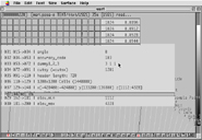
Reading a DEM file used as input, looks different. Some debugging information and a completion status bar appear.
Open surfPPC
Type b to set background to black or open preferences with o
Open with o
Space bar to render on a plane, 3 to render isometric view.
2
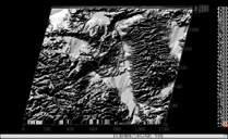
Rendered on the plane, isometric view.